everydayhiker

joined 3 months ago
 

Moderate, 8.8 mi Out and Back

1,804 ft elevation gain

Hiked 8/21/25

Flickr Album

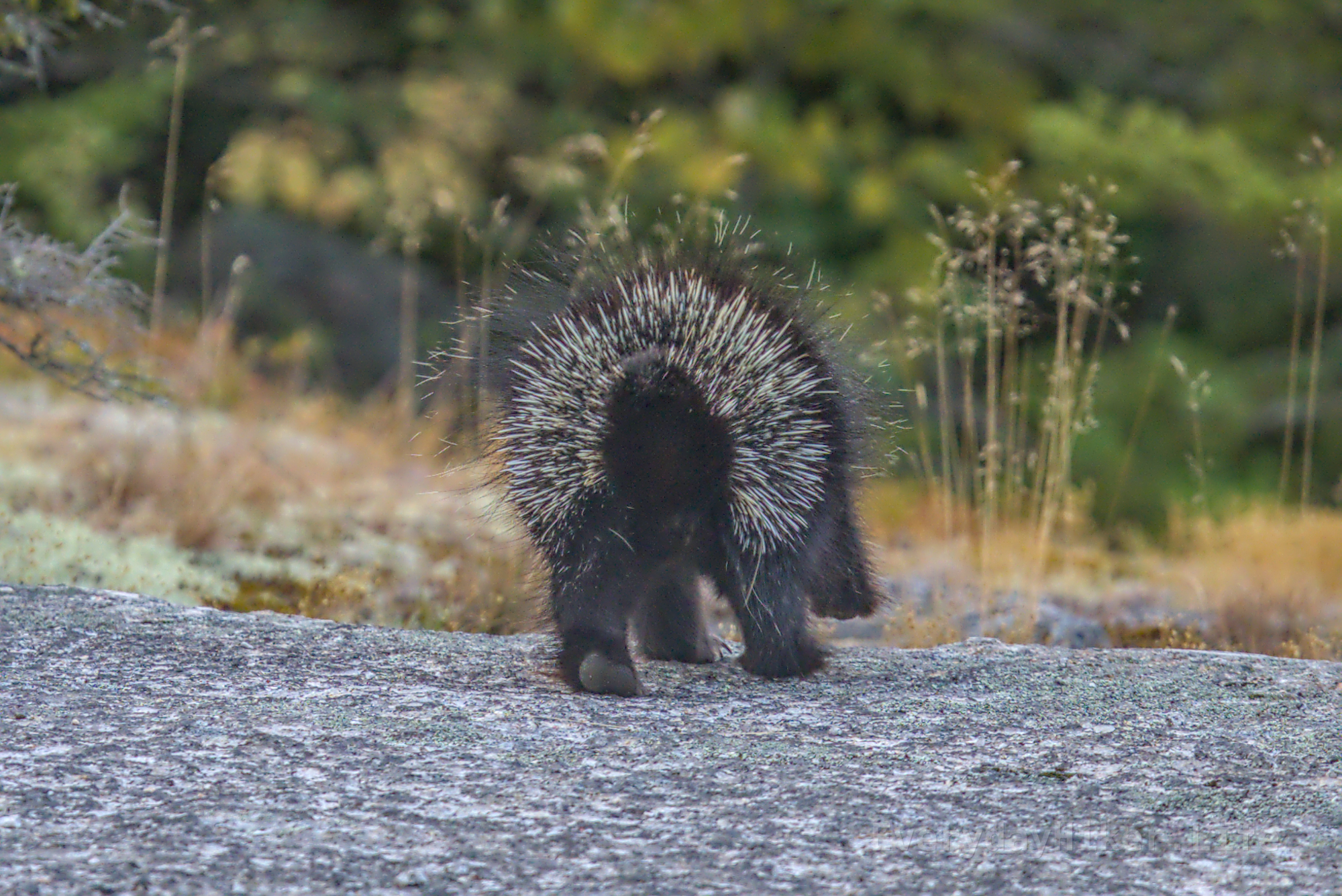
While hiking this short section of the Appalachian trail, I managed to spot this Porcupine up on a tree limb. When I first arrived, it was sitting like on a bench facing the sunset. Enjoyable hike with a few viewpoints, the summit being raised by a boulder pile to see over the treeline on Bear Mountain.

The forest at golden hour, in the lowest branch near center frame the porcupine may be seen.

Porcupine sitting in a tree, making sure I am not a threat.

Connecticut at dusk as seen from Lion's Head overlook.

A field of wildflowers under scattered clouds at sunset, located at trailhead.

[–] everydayhiker@lemmy.world 4 points 1 day ago

I just travel around and hike everyday that I can. Am based out of Oregon but travel out of a van nonstop. I finally started posting everything as a daily hike earlier this year (was on the photography page before recently switching to pics). Spent 3 months in Canada earlier this year and then now doing a loop through the NE, which I've never been to before.

[–] everydayhiker@lemmy.world 1 points 1 day ago

Haha, yeah I get around. Yeah, I really dug the inlet areas around there. Didn't get to explore as much as I'd like to, but very cool spot.


Easy, 1.9 mile loop

180 ft elevation gain

Hiked 8/19/25

Flickr Album

This easy stroll takes you to the intersection of Connecticut, Massachusetts, and Rhode Island (as well as a later connection of just CT/MA), with large markers delineating the boundaries. Not the most notable trail, but I have now been to Rhode Island. A nearby stream had this egret taking flight.

An egret launches itself upwards in flight.

View of the tristate marker showing the Rhode Island and Connecticut sides. This is the extent of my time in Rhode Island, so many memories.

Massachusetts and Connecticut side of the Tri-state marker.


Moderate, 6.3 mi loop

1,480 ft elevation gain

Hiked 8/18/25

Flickr Album

Pawtuckaway state park offers a variety is host to a variety of biomes, with this loop taking you to both of the mountain's low peaks and along boulder fields and a large wetland with a large diversity of wildlife. South peak has an observation tower open to public, and an active hummingbird feeder.

An Eastern Painted Turtle on a log, ripples from something that had splashed just before in the water behind it.

I believe this is looking west from the view tower, but I'm not sure what that mountain is.

Looking into the wetlands filled with lily pads and a beaver hut may be seen center right.


Easy 3.4 mi loop

364 ft elevation gain

Hiked 8/15/25

Flickr Album

An easy stroll in a community nature preserve I passed nearby while traveling. One of the routes will take you to a small coastline along one of the inlets of the Atlantic. A variety of birds to be seen as well of views of the many oyster farms in the area. Freshwater pond a little inland as well.

A more pebbly beach along the coast trail, with the oyster farms in view out in the bay.

A low flying Cormorant with its wings upraised.

Small boardwalk section through the muddier area. Dry when I was there.

[–] everydayhiker@lemmy.world 1 points 4 days ago

The rebar into boulder is certainly a throwback to the old days haha. I'd like to know how many people go up it a day, as I was there relatively early and it was already turning into one extended queue along the ledges.


Moderate, 7.1 mi One Way (Utilize Shuttle)

1,309 ft elevation gain

Hiked 8/12/25

Flickr Album

Utilizing the shuttle (transfer at the gardens) to combine the North and South Out and Back trails will allow you to hike the entire length of Acadia's tallest, Cadillac Mountain. First half provides view of Bar Harbor and the second quiet contemplation. Lots of sun exposure along route; water at the top.

The Porcupine Islands as seen from one of the early vantage points.

Looking southward as you continue along the wide open ridge line of Cadillac Mountain.

The summit of Cadillac Mountain, as seen from around half back down.


The Beehive, the Bowl, Gorham Mountain, Ocean Drive Loop

Moderate, 6.3 mi loop; not for fear of heights

1,142 ft elevation gain

Hiked 8/11/25 Flickr Album

An extended version of the Beehive loop adding trails in this section of the park. The climbing route up to the beehive consists of ascending several tiers of vertical ledges, with grips and bridges over delicate areas leading to a great view of Bar Harbor. Includes the popular cliffs of Ocean Drive as well as Otter point area (minus what was currently closed).

The view out from one of the tiers as you make your way up the face. Small bridge over a gap is easy to cross. I believe that peninsula is known as Great Head, with the Atlantic surrounding it.

Looking out on the Pacific in the early morning sun, a small pond reflects the clouds in its mirrored water on the right.

One of the cliff faces along the shoreline of the Atlantic Ocean near Thunder Hole.

[–] everydayhiker@lemmy.world 6 points 6 days ago* (last edited 6 days ago)

I saw another one (in a tree) last week and its got more quills on the underside than the top of its tail so I wonder if they keep it a little away so they don’t get themselves. I’ll have those photos posted in a few days. Had no idea porcupines were a thing in the NE, the other one was in Connecticut.

[–] everydayhiker@lemmy.world 4 points 6 days ago (1 children)

Haha, yeah I got a good view of its face first when I walked up, but by the time I could get photos taken it turned into a different kind of photo shoot.


Easy, 3.05 mi out and back 682 ft elevation gain Hiked 8/10/25

Flickr Album

Video on Flickr of porcupine scurrying away (also in that album).

A little north of Acadia National Park lies the Great Pond Mountain, which would be a fantastic place for likely both sunrise and set. I was just a touch late for the sunrise, which meant perfect timing for seeing a porcupine scrounging for breakfast. Views of Acadia were unfortunately under the fog.

The rear side of a porcupine as it lumbers away.

Looking south from Great Pond Mountain, Acadia National park is covered in fog.

Fog rolls through the lowlands of Maine.

[–] everydayhiker@lemmy.world 1 points 1 week ago

If you go the champney brook route to get there, there is also a waterfall on a spur trail on the lower end that is apparently nice. Person I was hiking with said it was dry right then so we just skipped it.

[–] everydayhiker@lemmy.world 1 points 1 week ago

Yeah, I’ve just started noticing a couple random trees turning here and there. I’ll bet when that all gets going it’s pretty spectacular.

[–] everydayhiker@lemmy.world 2 points 1 week ago (2 children)

Yeah, I really enjoyed my time there. What is it, 48 4kers I think? Hiked Mt Chocorua with a friend of a friend and I think that's what he told me. Although I guess that is all of NH, probably a good chunk just in the Whites. Out of my time here in the Northeast, I think that area has been my favorite so far.


Moderate to Hard 8.0 mi Out and Back

2,497 ft elevation gain

Hiked 8/8/2025

Flickr Album

After pulling back to back 4k's, I scaled it back with a 2.4k for day 3 haha. Great accessible hike that still has plenty of bite to it, with some scrambling at the very top. Adding Middle Sister gives a great view of picturesque Mt Chocorua. Still fairly hazy, but better than previous two days.

Looking towards Mt Paugus and surrounding area, and the Sandwich Range wilderness/Bowl Research area.

A look along the wide bald on top of Mt Chocorua, looking to the north. Bear mountain is the first mountain seen I believe, and more of the white mountains are often visible in the haze behind it than what is seen here.

The view from an old observation platform on Middle Sister, with the ridge running to Mt Chocorua.

[–] everydayhiker@lemmy.world 4 points 1 week ago

Thanks! Yeah, this is east coast too so i feel like I get beat up so much more by the trails out here. That’s a lot of down when its all rock stairs and boulders. Love that North Cascades area, well done yourself!

[–] everydayhiker@lemmy.world 2 points 1 week ago

Right on, thanks for the advice!

[–] everydayhiker@lemmy.world 3 points 1 week ago

Nice! Yeah that was my first time in new hampshire, and loved all three hikes i did in the White mountains.would love to do more in that area.

[–] everydayhiker@lemmy.world 4 points 1 week ago* (last edited 1 week ago) (2 children)

Title is phrased a little odd since I'm always just listing the name of the trail. Mt Washington is not seen in the title photo (technically that rock outcrop is Mt Washington though), but Mt Monroe and down the line on the presidential range is. I've been posting daily on photography, but may switch over to here for the daily trail photos. Mostly just because the subscriber count is higher, but if anyone has a particular place they'd like to see me post instead, let me know. Hiking is always an option, since that's what all these are based around, but the subscriber count is so low.


Hard, 9.96 mi loop

4,373 ft elevation gain

Hiked 8/7/25

Flickr Album

The tallest peak in the NE and second on the eastern seaboard, there are a variety of ways to get to the summit. This route provides varying scenery and a good section of the AT. Although it didn't pan out with the clouds, the sunset route down Jewell is the play, just don't forget your headlamp.

A neat looking transition from the sloped exposed rock to a more defined boulder stairs path. Small waterfall flowing along the watershed.

From one peak to another. Mt Washington as seen from the peak of Mt Monroe. Well defined trail may be seen climbing its way towards the top.

Steep stairs but a well maintained trail of rocks to make it easier as you near the summit of Mt Washington.


Hard, 12.3 mi out and back

3,845 ft elevation gain

Hiked 6/29/25

Full Photo Set

Adding roughly 1600 ft in elevation to the Goat Lake trail as well as crossing a very steep sided scree field with surprisingly good traction, with an epic view from the top. Once on the ridges its wide open, but you'll work to get there. Return the same route or a very long loop using Avion ridge.

Looking towards Newman Peak from the ridge line between it and Avion Ridge. A trail may be seen cutting along the scree to the right to get to the next ridge. It then ascends to the peak and can either loop or return the way you came. I was unaware of the loop and just came back across the scree field.

Looking Northeast from the pass below Newman Peak. Spread Eagle mountain in the distance and Yarrow creek flowing from the lake in the valley.

Photo of me on the pass below Newman Peak. The flat area was incredibly wide along this pass.


Moderate 8.7 mi out and back, connects to Newman Peak and Avion Ridge trails 2,217 ft elevation gain Hiked 6/29/25

Full photo set, incl. Newman peak and Avion Ridge Loop

2 miles are shared with a mostly level bike path, before it sharply ascends above the previously burned forest up a large valley with a many tiered waterfall in view as a motivator, or excuse for a breather. Above the falls is Goat lake, which is worth extending past a little even if ending here for one more view as it has a great view looking back from just before the next big ascent.

Looking back down the trail you just hiked. The trail may be seen cutting left then righ as it drops. Leftover trees from the 2017 burn leave their mark.

The first good viewpoint of the massive falls complex coming out of Goat Lake. Before the fire this would have likely been the first view of the falls you’d have at all as you emerged from the trees.

Looking out the upper bowl area back towards the way you came. I would consider coming up to this part even if you don't ascend to Newman Peak as its before any real elevation gain and offers better views than Goat lake.


Moderate, 9.1 mi out and back 2,264 ft elevation gain Hiked 6/28/25

Flickr image set

Generally mild until a steep ascent up a few switchbacks that get you to the upper twin lakes, this hike will take you along the valley between Rowe mtn and Mt Lineham and provides a variety of great views and wildlife opportunities. A lower Rowe lake is also accessed via a short spur trail. I believe the main Mt Lineham trail shares the milder first 3 miles.

Trail photo showing the up and down from a switchback. While steep, it has great traction throughout. A section of Mt Lineham is seen on the left.

I believe this is considered Rowe Mountain, but I could be wrong. Passed on the left as you go along the trail. Seeing water cascade down the slide area would be a treat.

The creek flow out of Rowe lake left some snowbank overhangs which were great from waiting out the rain.

view more: next ›